
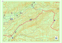
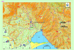
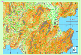
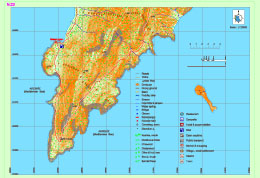
Lycian Way
| Teke peninsula, which is located between the Antalya and Fethiye gulfs in the Mediterranean region, was named as Lycia in ancient geography. The southern border of the region is its coast to the Mediterranean Sea, while its eastern, western and northern borders changed throughout the history. According to the ancient writers, Beydağları which start from the west of Antalya and extend to southwest, Akdağ range and their extension to the northwest defines the northern border of Lycia. In the famous epic poem Iliad, Homer states that the Lycians, which were commanded by Glaucus and Sarpedon, supported the Trojans against the Achaeans. |
Lycia came under the dominance of the Persians after 545 BC and supported the fleet that was formed by the Persian King Xerxes for the conquest of Greece in 480 with 50 ships. The Persian occupation ended when Alexander the Great crossed the Bosphorus to Anatolia and defeated the Persians in 333 BC in the Battle of Granicus. After the death of Alexander the Great, Lycia came under the dominance of Ptolemaic dynasty in Egypt, which descended from the general Ptolemy, from the year 309 BC for 100 years; this is known to be the period in which Lycian language was forgotten and replaced with Ancient Greek.
The region has been ruled by the Syrian King Antiochus III between the years of 197 BC and 167 BC. Lycia received its independence from the Roman Empire in 167 BC. During this period, 23 cities united and formed the Lycian League, of which the capital city was Xanthos. According to inscriptions and ancient coins the League had its monetary unit.
Strabo states that the six biggest cities of the Lycian League were Xanthos, Patara, Pinara, Olympus, Myra and Tlos. The Miliarium Lyciae, which is the map of the Lycian region with distance units and routes connecting the settlements, is the oldest road map known. During the Roman Empire period, the League did not lose its function and reached maximum level of prosperity during this time. The city populations were around 5,000 and the total population of the region was approximately 200,000. The borders were pushed further as to include Kaunos (Dalyan) in the northeast.
Around the middle of 5th century, there were 34 cities ruled by the Proconsul of the Lycian State. The region between Demre and Kaş was the most populated area in Lycia. The amount of settlements per kilometer is nearly 30 in this region. Introduction of Christianity to Lycians did not occur until the visit of St. Paulus to Myra and Patara at his third missionary journey between the years of 53 and 57. Methodius of Olympus was the first known bishop of Lycia and he was executed in 312. The Byzantine period between 4th and 7th centuries was the period in which Christianity was adopted and many churches were built in the region.
One of the most prominent changes that occurred during the said period was the start of monastery settlement constructions, especially in the mountainous areas of Demre. Monasteries were very important points of power which had influence on the economic and public life. The monastery life in Lycia started as early as the 5th century. The fact that many large churches were built during the 5th and 6th centuries indicates that the population of the region was very high during the said period.
Most of the Lycian coast is formed of rocky terrain. This type of topography has allowed for natural harbors to be shaped at some locations. Strabo has expressed that the Lycian coastline is rough and difficult to pass through, while the harbor is very well-equipped. Maritime trade, which existed in the region since the Bronze Age, became diversified in the following periods and lasted until the Roman and Byzantine Periods. Purple dye, cedar wood, olive oil, wine and sponges are the key goods that are produced in Lycia. According to ancient sources, high quality and soft sponges can be harvested at Antiphellus and the area surrounding it. In addition, the quality of the cedar wood in Lycia, which is used in shipbuilding is rather high as well.
The harbors in Lycia can be named as Idyros, Phaselis, Corycus, Olympus, Posidarisus, Melanippion, Gagae, Phoinikos, Andriaca, Simena, Teimussa, Aperlae, Antiphellus, Kalamaki, Phoinike, Patara, Pydnai, Arymnessos/Perdicia, Calabantia, Karmylassos, Telmessus, Krya, Lisse and Lydai, respectively from east to west.
Of these harbors, Andriaca and Patara is distinguished from the others in that they possess political and economic power, in addition to being an internationals trade point. By virtue of its local traditions and distinctive architectural style, the region is the most interesting area in Anatolia; the cities of the region are generally located on the coasts and the valleys of Xanthos and Arycandus, which are considered to be the core of the region. Some of the texts that belong to the Lycians, who were known for having their own language and alphabet, were translated into modern languages; most of these are epitaphs.
The region of Lycia consists of cities of large, medium and small scale, port cities, military zones, farm settlements and towers. Most of the visible remains in the region belong to the Roman and Byzantine periods. The most encountered types of remains in the traditional settlements concentrated in the mountains are olive oil and wine workshops, and agricultural terraces. These rural settlements, in which most of the population lived, provided food for both themselves and the large cities.
The residential structures in Lycia are generally divided into four groups. The first group consists of adjacent residences in which each room has its own entrance. The second group is made up of stand-alone residences of one or two rooms in rural settlements. Both types of residences in these groups are generally two-storey houses that are located collectively or closely within walls of the settlement. The third group consists of single-storey residences with two to four rooms in agricultural areas of which some has courtyards, cisterns and workshops, while the fourth group is made up of residences of mostly rich people in rural areas, which are built as rooms surrounding a courtyard which is positioned in the middle.
Natural disasters and epidemics that occurred in the region have deeply affected the lives of those in the cities. The most prominent of these are the earthquakes that occurred in the years 141, 240, 385, and 529, and the plagues that happened in the year 542 and the period between 1346 and 1347. Due to the blights that were suffered in the coastal regions, the settlements in the inland areas came into prominence. Emperor Constans II fought the Arabians in 655 on the coast of Phoenix with the fleet he personally commanded. After being defeated, the Emperor managed to survive by way of the self-sacrifice of a young soldier. After this battle, the Arabians began navigating freely near the Mediterranean coasts.
In 802, the regions of Lycia and Caria were occupied by the Abbasids. During the 10th century, Lycia and the whole of the Mediterranean region were under the domination of the Byzantine Empire. Turks acquired access to Lycia after the Seljukian Sultan Kılıç Arslan II defeated the Byzantine army. After 1204, the whole of Lycia came under the domination of Turks.
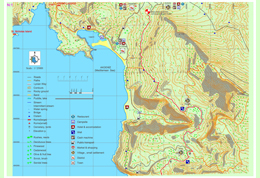
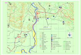
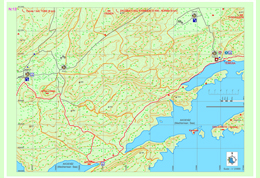
Ovacık-Kirme (Kayaköy)
Even though the Lycia road is accepted officially as being started at the south of Ovacık town, at the crossroads of an asphalt road which is located on the east (mountain) side of a road as parallel to Ölüdeniz road; there are other archaeological settlements such as current Fethiye and previous name Termessos which was accepted as the western border of known Lycia civilization and Kayaköy which was known as Karmylassos.
You can reach to Ölüdeniz Lagoon after a walk with view of both forests and sea and Kayaköy after crossing the pathway which was signed with different colors as a walking road but not as Lycia road, which has stone masonry on some of its sections between Ölüdeniz and Karmylassos (Kayaköy) which is one of the biggest settlements of Lycia. From there after a break in Ölüdeniz town center from vehicle road, another pathway which goes South at the end of Belcekız beach on the road located at the mountainside and linking to Lycia road located above, you can reach Lycia road.
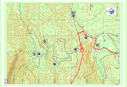
Faralya – Kabak- Alınca
The Lycia road which goes on downward from Kirme settlement, reaches to the asphalt road of Faralya settlement after passing near large and small water sources. Faralya village settlement is located at a very special location in terms of flora, on a slope overlooking the south at the mountainside of Babadağ and just above the valley of butterflies. It contains most endemic plant types.
The minibus coming from Ölüdeniz, reaches to Uzunyurt or even Kabak settlements after passing from Faralya. At Faralya there is a market and shopping opportunity. Accommodation in camp, bungalow and Mediterranean type hotels made from stone is available. Before passing Faralya if you turn towards right from the main road, the peerless view of the valley of the butterflies can be seen. There is even a pathway reaching to the camp site located down at the valley downwards from this turn. The descent is made by hanging to the ropes set on crags. This is extremely dangerous for the people with heavy loads and amateur walkers.
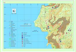
Gey – Bel ; Boğaziçi – Sidyma
In the Alınca settlement the pathway of Lycia road which is separated from the asphalt road, goes towards south along the slope overlooking the sea at the west side of the Eren Mountain. The pathway going downwards from the Üçkeçi region in which there are bee hives to Cennet Bay, separates from the Lycia road. The pathway which goes on towards south for a while, reaches to a flat valley on which there are stone terraces on some parts.
One can reach to Pirate bay with the pathway separating towards right after the first cistern to be seen here. Along the Pirate bay and the cape located in south Kalabantia archaeological settlement can be seen. If one goes on from the marked Lycia road without leaving, this Lycia road splits into two before a village home, and at the right side it goes on from Gey and Yediburunlar towards Bel settlement.
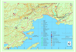
Belcekız – Gavurağılı – Kumluova
The Lycia road splits towards right after a couple of kilometers from the dirt road which splits towards southeast, on a flat area with its red soil, ancient olive trees, carstic limestone and plants indigenous to the Mediterranean seems just like a man made ornamental garden and elevates through high pine trees towards a channel after a region called Belcekız.
After the channel it starts to descend from a steep slope in zigzags. In this region in which the characteristic Lycia road signs are erased, if one goes on to descend from the slope towards southeast, after a while they can reach to the flat areas at the west of the Gavurağılı settlement. A long slope descends ends after passing a stone masonry pathway. The pathway which goes on for one km among the trees and fields, reaches to Gavurağılı settlement.
Kumluova-Letoon-Kınık-Ksantos-Çavdır
Before coming to Kumluova, the road goes on through the sandy land covered by eucalyptus trees and shrubberies, then goes on to the left from the location of the fountain. It is not recommended to drink from this fountain. The pathway crosses the bridge after a while and goes on towards the Kumluova – Gerenovası settlements which contain lots of greenhouses. From the road, Letton ruins can be seen. After the Letoon ruins, when going towards east, it goes on until the edge of Eşen River.
It also goes on to north parallel to Eşen River. Karaköy and from the other side of the bridge Kınık settlements can be seen. This is the first settlement which contains a bank or ATM access from Fethiye on the Lycia road. Across the bridge at the left side, if one goes on upside from the asphalt road from passing in the middle of the bazaar area Xhantos ruins can be seen. After the ruins the pathway goes on parallel to the asphalt road in the forest. Lycia road signs in this area were erased. When you go on to east parallel to the asphalt road, you can see the interurban road intersection.
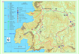
Çayköy-Üzümlü-İslamlar
When going towards the right from the three lane intersection south of Çaydır Settlement, the road goes on to first a graveyard and then when continued to an olive grove towards the top of the hill. An old Roman bridge draws attention in the area. Lycian pathway reaches to a village road over the Çayköy settlement. After a while when the pathway starts again it goes on parallel to the waterways.
After a second Roman bridge has been passed it goes on from a dirt road under the pine trees. At the end of the forest are you should pass from an area with dense thorns. Pants or legging use is suggested especially in this area. Lycian road which goes on partly as natural pathway, and at some points from the asphalt, reached to Akbel after a couple of kilometers of descend from İslamlar settlement.
In this map section market is only located in Üzümlü settlement on the Lycian road. In the İslamlar settlement there is a business providing accommodation and also there is another market which is not so close to the Lycian pathway. After 2km from Üzümlü settlement and 4 km, drinking water can be obtained from two different fountains. Going upwards from the river bed in the Üzümlü settlement and deviate from the Lycia road, there are four different areas of remains in the river bed until Yeşilce settlement.
Akbel – Delikkemer – Patara
The road which goes on the asphalt reaches to Akbel after 1 km south from the İslamlar (podamya) settlement. When you go right from the cemetery and left from the first opening when going towards the mosque and then take the first right from the opening, the pathway goes straight from near the school and then when you cross the Antalya asphalt you see the Delikkemer sign. The pathway goes on asphalt from Akbel to this point and then goes on with a view of Kınık-patara valley for 6km inside shrubberies.
When reached to Delikkemer the road splits into two. One goes towards Kalkan and the other goes towards Patara as parallel to the Delikkemer. When passing near Kemer the Patara table is shown. At the dirt road on left the Lycia road signs are partly erased. At the left side Fırnaz bay and Kalkan view can be seen. After going straight for 2-3 kilometers the road goes on in zigzags and reaches to Pınarkürü.
Kalkan-Bezirgan-Sarıbelen
One could proceed 3-4 km through the asphalt from Akbel to Bezirgan with a view of Kalkan. By turning left from the old water cistern on the road, an inclination begins towards the hilltop from the stony pathway with zigzags. This could be a steep and tiring climb. After the peak and walking from stony pathways, old but still usable granaries can be seen. You can proceed on the asphalt until Bezirgan village square.
Drinking water can be obtained after Kalkan district only from the fountains in Bezirgan. Also there is a market at the center for basic shopping needs. Then there starts a climb from Bezirgan towards the main road. After proceeding towards the TV transmitter from the dirt road near the main road, and after walking for a while you can pass to pathway from the dirt road and then the descend starts from among the shrubberies. Lycia road signs were partly erased in this section.
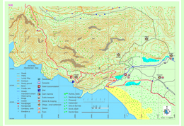
Gökçeören – Gökdere
Accommodation and eating-drinking needs are being supplied by the local people in Gökçeören. The road goes on the asphalt for a while starting from Gökçeören and later from a dirt road goes on as parallel to river bed. After a long descend with a gentle slope the sight of kara dere (kara river) which flows both in summer and winter, a climb starts towards the hill across the river. After a couple of hours of climb there is a flat area and then there is a couple of abandoned houses.
Then a place which is appropriate for camping and with drinking water and also with a large sycamore tree can be seen. After this point Lycia road signs were erased mostly due to the road construction work. The road goes on sometimes as dirt and sometimes as pathways. If one is to go 7-8km from the pathway from Hacıoğlu settlement to northeast, Kandyba ancient settlement can be seen.
Çukurbağ – Pınarbaşı
The road which goes among the thorns in some places until Phellos had become extremely non-visible at some points due to the new road construction works. After a gentle slope towards the hill, the ruins of Phellos can be seen and the n the pathway takes us towards the entrance of the city. It turns towards Çukurbağa without entering into the city. It then continues to descend perpendicular to Çukurbağ for a couple of kilometers. From the village mosque one could reach to village center.
There are no markets in the village but there are drinking water wells in multiple locations. Lycian road goes inside of Çukurbağ and after passing long flat areas and fields reaches to a point overlooking Kaş district from a hill. The ruins registered with the name of Pınarbaşı at southern together with Pınarbaşı settlement without leaving from the road when descending towards Çukurbağ down from Phellos.
Kaş – Limanağzı
Lycia road goes from Çukurbağ towards south and descending from a terrace overlooking Kaş district in a perpendicular way and passes from Kaş settlement. Kaş district is a center in which needs such as public transportation, market, bank, accommodation etc. can be met. For the ones who will go on towards Limanağzı direction, they should move on with keeping in mind that there is no other settlement until Boğazcık – Kılınçlı settlement for obtaining the needed resources.
The road goes on towards the Büyükçakıl beach from an asphalt road parallel to the sea inside Kaş district and after passing the beach the road turns right and climbs towards the settlement area and then from there goes on as a dirt road. Before coming to Limanağzı area first Sebeda archaeological settlement is seen and after some little side passes with the help of the ropes in front of rock tombs overlooking the sea, some needs can be obtained from the businesses in Limanağzı bay. The pathway goes on among fields, stony areas and narrow dirt tracks in some parts and then turns towards the seaside again after a couple of kilometers from Limanağzı.
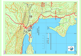
LİMANAĞZI (SEBEDA)
In this region which is named Bayındır port today the name of the town which contains Bahtsız and Kavgar hills is known as Sebeda. Town is set up around a secured port and it is a little farm settlement belonging to the Lycia period with its oil extraction workbenches, cisterns, rock tombs, sarcophaguses. There are Lycian type room tombs cut in natural stone dating back to 4th century B.C. at the slopes overlooking the sea of Bahtsız hill and at seaside there are the remains of buildings which can be related to the port usage and estimated to had been used as warehouses. At the hilltop there is an open air temple which is formed with the flattening of a natural stone on which there are sarcophaguses and niches. The ruins of the building over the Kavgar hill which can be reached with a pathway thought to be used in ancient times, is thought to be a watchtower. There are tombs around the watchtower belonging to Lycia and Roman period some of which containing inscriptions over them.
Limanağzı – Boğazcık
Passing from the neck of the peninsula starting from the point where Limanağzı is located and after a mild climb, Lycian road goes on from the seaside and continues parallel to the shore with sharp white stones and reaches to Çoban bay. By descending from the hill just above the bay again Fakdere region could be reached. At the end of the cape located south of Fakdere, there are the remains of the ropes used in unearthing the world’s oldest sunken ship which is exhibited in Bodrum museum.
At the eastern end of the bay in which Fakdere is located there is an old cistern and ruins. From the guardhouse in Fakdere drinking water could be obtained if necessary. One could reach after climbing the hill on the east and first from a dirt road and then from a pathway which consisted of round, carstic lime stones and red soil to a region called Üzümlü pier among the rubble stones just next to the sea with olive trees. The road goes parallel to the shore and goes on through a bay adorned with white very sharp marbles and under carob trees.
Boğazcık – Üçağız
From the entrance to the Boğazcık settlement towards the right side through the Lycian road it is possible to obtain drinking water, food and even accommodation from the village homes. Lycian road goes towards right from the entrance of the village and left from above the hill and goes towards the hill on which Appollonia archaeological settlement is located.
After following the asphalt road at the slopes of the hill on which ruins are located for a short time, it turns right and after descending from stony lands and passing from pathways of red soil among the olives, Aperlai archaeological settlement could be reached. It reaches to the other lagoon at east after going on as parallel to the ruins from red colored fields through a gap between the lagoon northeast of Kekova Island and the lagoon in front of the ruins. From here towards the north hills one could descend from a hill overlooking Kekova and Üçağız after passing some flat areas on which there are large trees and enjoyable pathway.
Simena – Kapaklı – Andriake
The road advancing from between the houses behind the square of the Üçağız location leads to the dockyard after 2-3km of earth road. The road winding along the coast where the dockyard is located advances across the plains where there are only a few houses, fields and a cemetery and a water fountain. After reaching the cove, the road splits up from the cove by passing through the ruins overlooking the cove.
Lycia road path advances with a slight upward slope until Kapaklı village, but without entering the residential region, the road starts to re-descend from below the village and reaches the sea cost. You can reach Andriake from the gravelous beach and you can get to the highway if you take the narrow pathway to the right after passing by firstly the wooden bridge and then the archeological settings in Andriake. From this place, you can catch a sight of the St. Nicholaos Church in the district of Demre and then get to Myra archeological settings.
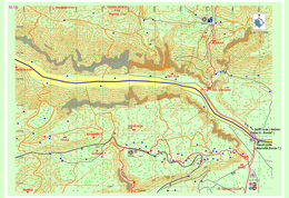
Gürses – Demre – Belören
If the road to the left-up is to be taken at the Lycia junction before the Andriake settlement, the pathway passing through the Sura ancient city, ascends on a canyon with an ancient stepped entry after Sura. The pathway going up from the valley joins the asphalt road and advances parallel to Gürses settlement and occasionally passes through bushes and thorn patches. The pathway advancing through cisterns and ancient ruins until the city walls above the Myra ancient city, leads to the front of Myra by descending down from the city walls.
The pathway advancing to the right (sea side) before Andriake, passes by The Church of St. Nicholaos after passing by Andriake settlement and advancing along the asphalt road until Demre city center and joins the other pathway ascending in front of Myra. If advanced to the north from this point in Demre district, Demre stream is crossed over with a bridge. At the exit of the bridge, the Lycia pathway diverges again.
Zeytin – Alakilise – Bonda T.
The Lycian road, which ascends via the path beside the dirt road at the exit of Belören settlement, reaches the settlement of Zeytin by passing a wide plain. After passing Zaytin, the dirt road is continued to be followed for a short while; afterwards the path to the right is taken. The path descends for some time and then enters the woods from among the village houses. At the hill, the dirt road is once again followed for a short while and then the road becomes a path again, descending to Alakilise.
After Alakilise, a gentle climb and then a steeper climb must be done. Passing below the archaeological remains known as Papaz Kayası, the path ascends to the top of the mountain. After this point, the path follows the hillsides and ascends through wooded areas with gentle slope. The northern route of the Lycian road, which descends from very high altitudes while providing a view of the lagoon before Beymelek, becomes unfavorable to walk in the winter due to snow buildup on the paths. It is advised for travelers who will be taking this route to carry sufficient water for this part which will take two days between Belören and Finike.
Kınık – Yukarı Beymelek – Bonda T.
As an alternative to the northern route that can be seen in Section 16, the southern route which goes right from the bridge on the main road that provides crossing over Demre creek can be taken after the ancient settlement of Myra. The route continues along the asphalt road and ascends through the Kınık settlement that is 1,5 kilometers further; then it enters scrubland. The path, which progresses among scrubs that are the typical vegetation in the Mediterranean, reaches the main road within the village by passing in front of the Ision ruins.
The southern of the Lycian road which continues to go south (towards the sea) skirts around the lagoon by heading east after reaching the main road at the coast. The route continues on the ancient road which ascends to the east from the opposite of the strait side of the lagoon where the lagoon meets the sea and climbs up the Bonda Hill where many archaeological settlements exist.
Bonda T. – Finike – Sahilkent
Two paths, coming from south and north, merge further up from the Bonda Hill and around the Dinek Hill. The combined path descends to the Finike district via patches of scrub and pine woods, sometimes intersecting with dirt roads opened for vehicles. While there are no set centers of population along the Lycian road, which will be following the coast for 20 kilometers after the district of Finike, there are some summer houses on the coast.
However, it can well be said that the most suitable location for acquiring food, water, accommodation, etc. is Finike. The archaeological settlement of Arycanda, which is one of the biggest in the region of Lycia, can be accessed after an approximately 1-hour journey with vehicles via the main road that goes north within Finike. If the Lycian road is continued to be followed through Finike, the archaeological settlement of Limyra can be visited after following the creek that goes north from the Sahilkent settlement for a few kilometers.
Sahilkent – Hasyurt – Kumluca
The entirety of the Lycian road that is within this section progresses on the coast, parallel to the sea. If the travelers wish to do so, they can part from the Lycian path, follow the main road to the Kumluca district and visit the archaeological settlements of Rhodiapolis and Korydalla.
CORYDALLA
Corydalla, which is located in Hacıveliler Village, expands on two hills and their skirts. Corydalla was represented in the Lycian League together with Gagai and Rhodiapolis and even though it was not the largest of the three cities, it was the leader among the three.Most of the ruins, such as the remains of the theatre, which were identified in the late 19th century and the early 20th century, could not survive until our day. The most attention-drawing structures in Corydalla are the bathhouse, waterway, the cisterns on the Small Asar Hill and the Large Asar Hill, rock tombs and a mosaic tiled building of which the walls were built with meticulous workmanship. Rather than the structural remains in it, Corydalla is essentially known for its treasure, which was dug out after an illegal excavation, of which a part was smuggled abroad and which had a special place in the Byzantine metalworking art.
Mavikent – Karaöz
The entirety of the Lycian road within this section progresses on the coast in parallel fashion to the sea. On the coast, in the south of the Mavikent settlement, the settlement of Gagai and aqueducts can be seen. Even though the section legend includes markings indicating a grocery or settlement, it is highly probable for the settlements within this section, especially the ones on the coast, to be empty during the winter since these locations are generally inhabited during the summer for vacation purposes. Particularly, the stores for food and water can be accessed in the summer.
GAGAI
Gagai, which is located within borders of Mavikent Town in Kumluca District, Antalya Province, was established on the hill at north of the white limestone mound on the beach, the skirts of this hill and the plain in front of it. The name of the settlement is referred to as “Palaion, Teikhos or Old Castle” in ancients sources.
While most sources cite that the city’s name was derived from the word “ga” which meant “earth” in Doric, or that it was derived when a Rhodian commander named Nedius came into danger with his ship after winning a battle against Lycian and Cilician pirates and his crew shouted “ga ga” upon seeing the land, it is presumed that the name Gagai was derived from the word “hahha” which is spelled “gaxe” on coins with Lycian inscriptions and which is originated from old Anatolian languages.
Karaöz – Adrasan
Because of the layout of the Lycian road sections, the Lycian road part shown in this section reaches the settlement of Karaöz from the coast and continues towards the cape in parallel fashion to the dirt road. This part is shown in Section 22. The Lycian road moves around the slope where the Gelidonia Lighthouse is located at further south and via the forest path, arrives at the settlement of Adrasan, as seen in Section 21 again. The Lycian road passes the Adrasan coast and moves upwards from the creek basin at the end of the coast.
Upon the asphalt road, at the point where the lodging houses and restaurants end over the creek basin, the Lycian road moves toward right and ascends in the direction of the Olympus settlement. The settlement of Adrasan is the only settlement within this section in which essential needs such as food, water, etc. can be met.
Korsan Koyu – Gelidonya Feneri / Korsan (Pirate’s) Bay – Gelidonia Lighthouse
At this part of the Lycian road, the path moves from the settlement of Karaöz to the south and continues via a dirt road and parts left from this road at the end part of the peninsula. The path then ascends within the forest and arrives at a slope viewing Cape Gelidonia and the Gelidonia Lighthouse.
The path ascends a little more by following the slope of the hill, after which it starts to decline within the forest. The path then continues towards Adrasan in parallel fashion to the coast, which provides the travelers with a view of the sea for a while. Within Section 22, the only source of potable water is the fountain that is located at the ancient settlement which is indicated as Melanippe (Korsan [Pirate’s] Bay).
Adrasan – Olympos
The path which comes from Adrasan, goes through the forest and climbs to the northern slopes of Musa Mountain from within the valley. It starts to descend from around the settlement of Olympus. After progressing through a landscape of sandalwood forest and continuing paralele to the creek basin at the side of the valley, the path reaches the coastal settlement of Olympus and the archaeological settlement of Corycus. There are no food or water resources along the path. The only location on which needs for food, water, etc. can be met is the coastal settlement of Olympus.
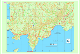
GENOESE BAY
While Genoese Bay is referred to as a safe haven in the marine guides of 14th century, the bay which is marked in the Map of Piri Reis is defined as on of the most important harbors of Lycia by some of the 19th century travelers.
Olympos – Çıralı
The path, which arrives at the coast in the coastal settlement of Olympus, follows the Çıralı coast and forks into two routes, namely the western and eastern routes. The path following the eastern route runs near the sea at a low level, skirts around the bays and continues towards the Phaselis archaeological settlement.
The path that goes west ascends to high levels towards Ulupınar and Beycik and continues at a high level towards north in the direction of Tahtalı Mountain. There are facilities that will meet essential needs such as food, shopping and accommodation in both Olympus and Çıralı within the section.
Ulupınar Beycik
The western path of the Lycian road (the western route), which continues through the pine forest from Chimaira (Yanartaş) to the north, passes through the Ulupınar settlement and progresses toward the settlement of Beycik by ascending within a Turkish pine forest.
The road goes parallel to the main road near the upper Beycik settlement and continues to ascend steeply towards the strait on west of the Tahtalı mountain. In the section, needs such as food, accommodation and shopping can be met in Ulupınar while upper Beycik will meet the same needs as well.
Tekirova – Phaselis
The eastern route of the Lycian road, which forks at Çıralı, passas through various bays on the coast and descends into Tekirova settlement. It progresses for a long while on the plain where the town is located, goes towards north and reaches the Phaselis archeological settlement. Within this section, all needs, such as food, accommodation and shopping can be met in Tekirova.
PHASELIS
Phaselis, which is within borders of Tekirova in Kemer district, Antalya province, and draws attention due to its natural beauty as well as its archeological value, was established by the Rhodians around 650 BC. The city was especially rich and powerful during the classical age. Phaselis people, who prospered by means of marine trade, are infamous due to their slyness and deceitfulness.

Tahtalı Dağı – Yayla Kuzdere
The western route of the Lycian road continues to the north from the Beycik settlement and passes across the strait on the west of the Tahtalı Mountain. It runs through centuries-old cedar and juniper trees and snowy hollows. Eventually, the road descends onto a small plain in the middle of which a single house rests. Before arriving at this point, a path that detaches from the road can be taken to access the peak of Tahtalı Mountain.
The small plateau on which the house stands is inhabited during summer, while it is under heavy layers of snow in the winter. It provides potable water by means of the fountain between tree hollows, at the south of the house.
Read more: Tahtalı Mountain – Kuzdere Plateau Map Section 27
Phaselis – Çamyuva – Kuzdere
The road begins from the archaeological settlement of Phaselis and first continues in a route parallel to the sea, then carries on towards the Kuzdere settlement through Turkish pine forests and on the banks of the creek.
Information regarding the archaeological settlement of Phaselis are provided on the page for Section 26. The settlement of Çamyuva is suitable for meeting essential needs such as food and accommodation.
IDYROS
Ancient sources do not contain much information on the ancient city of Idyros. Carl Ritter has stated it is said that “the city which is a ship haven of the ancient ages located around Egber which can be accessed by going north from Phaselis and over the northern slope of Cap Avova, is Idyros Polis”. Skylax has written that the city of Idyros is located between Phaselis (Tekirova) and Lurnateia (Sıçan [Rat] Island). Kipert has indicated that the city is in the bay on the southeastern coast of Kemer Mountain.
In 1977, as a result of the excavations carried out at the back of the Ayışığı facilities for excursionists on the coast in Kemer by the Ministry of Culture and Tourism, the city remains in this area were identified as to belong to the Idyros ancient city. The excavations revealed a Byzantine church and civil architecture structures surrounding it, in addition to tombs from classical and Byzantine periods.
Yayla Kuzdere – Gedelma / Kuzdere – Gedelma Yol ayrımı
The western route of the Lycian road, which parts from the main road, crosses through forests, gardens and other roads from time to time and eventually reaches the settlement of Gedelma. From the Phaselis area, the road first goes through Kuzdere settlement and follows the main road which passes through the Kesme Strait and its canyon, after which it is connected with the eastern route of the Lycian road which reached Gedelma.
Lycian road, which follows the asphalt road that ascends to Gedelma, parts from it after a few hundred kilometers and continues towards the Göynük Plateau from within the forest. The best place in this section where needs for eating, shopping, etc. can be met is the Gedelma settlement.
Göynük Plateau – National Park of Göynük Canyon
Lycian road, which extends from the settlement of Gedelma, goes through small settlements such as Meşeçukuru, etc. and reaches the settlement Söğütçük. The common name of the settlements here is known to be the Göynük Plateau. Lycian road runs parallel to the road below and runs directly on the road below from time to time until it is separated from it and leads down to the Göynük creek.
The route goes through the creek for a while and after the creek is crossed via wooden stairs, it goes up and down a hill into another creek basin, after which a long climb starts. Trekkers who walk below from the Göynük Plateau and towards the canyon should pay attention to the information given below:
Sarıçınar – Hisarçandır
The part of the Lycian road here rises from within the valley in the National Park of Göynük Canyon to the north and turns towards the peak of Sarıçınar Mountain through the end of the valley The road becomes stabilized at the skirts of the mountain and after going through a highland settlement with a few residences, reaches the settlement of Hisarçandır, the official beginning point of the Lycian road.
It should be noted that the Lycian Road continues until the archaeological settlement of Trebenna, which is located near the Çağlarca village in Geyikbayırı, Konyaaltı district, Antalya province and is known to be the last city on the eastern side of the Lycian country. After the marking of ancient road remains which start from the settlement of Hisarçandır, goes through the archaeological settlement of Typella and the skirts of Sivridağ, and reaches the archaeological settlement of Trebenna is completed, the official starting point will become the Akdamlar village, which is nearby, and the maps will be updated in accordance with this.