
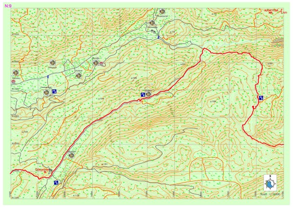
Gökçeören – Gökdere
Accommodation and eating-drinking needs are being supplied by the local people in Gökçeören. The road goes on the asphalt for a while starting from Gökçeören and later from a dirt road goes on as parallel to river bed. After a long descend with a gentle slope the sight of kara dere (kara river) which flows both in summer and winter, a climb starts towards the hill across the river. After a couple of hours of climb there is a flat area and then there is a couple of abandoned houses.
Then a place which is appropriate for camping and with drinking water and also with a large sycamore tree can be seen. After this point Lycia road signs were erased mostly due to the road construction work. The road goes on sometimes as dirt and sometimes as pathways. If one is to go 7-8km from the pathway from Hacıoğlu settlement to northeast, Kandyba ancient settlement can be seen.
GÖKÇEÖREN ANCIENT SETTLEMENT
At the center of the Gökçeören village of which old name used to be known as Seyret, there is a settlement area used in the Hellenistic and Roman period starting from Classical Era at the hills located right and left of the road at the exit of the road continuing towards Sarıbelen – Kalkan.The hill which is in oval form at the north and rock tombs at its slopes; shows that this is the necropolis of the settlement. The hills on the south side are the main settlement area. There are the ruins of a rectangle shaped building which could have the properties of an inner castle of a watchtower. At the slopes of these ruins there are housing areas interlocked with rock tombs. The architecture of the buildings and their wall masonry proves that this was a rich settlement at its time.


KANDYBA
Ancient Kandyba on the borders of Çataloluk (old name Gendiye) Village which can be reached from the mountain road west of the town exit of Elmalı-Kaş highway is located on the natural height with a look of an oval table and descending from west towards east. Its west-north and east sides are covered with rock faces however its south side was made protectable with a parapet. City gates which can be reached with stairs from south side is protected with two towers.
Its acropolis has a narrow and long summit of 180 meter in height which goes towards north-south direction. The city wall belonging to Middle Ages lies on the ancient foundations ruined due to neglect. All other public buildings and theatre are destroyed now except for a building which could be identified recently as a palace belonging to early 5-4th centuries made by cutting the rock at the southern end of the acropolis. It is being guessed that the east of the acropolis was left to the housing. Some finds in the town proves that it was inhabited for a short time in early Byzantine period.
There are rock tombs at the east and south slopes of the acropolis and there is the Necropolis area with its sarcophaguses and tombs cut in native rock at the northwest slopes. Two of the rock tombs contain inscription in Lycian and the red paint on one of the tombs is still preserved. One of the most important features of the Kandyba settlement is the granary which was made in the form of a Lycian type tomb monument. Nearly 20 granaries were spotted made on a high stone foundation, all wooden and with the interlocking of wood beams.