
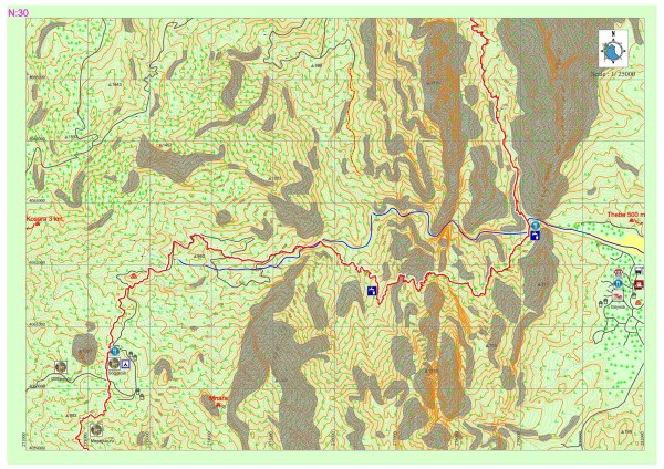
Göynük Plateau – National Park of Göynük Canyon
Lycian road, which extends from the settlement of Gedelma, goes through small settlements such as Meşeçukuru, etc. and reaches the settlement Söğütçük. The common name of the settlements here is known to be the Göynük Plateau. Lycian road runs parallel to the road below and runs directly on the road below from time to time until it is separated from it and leads down to the Göynük creek.
The route goes through the creek for a while and after the creek is crossed via wooden stairs, it goes up and down a hill into another creek basin, after which a long climb starts. Trekkers who walk below from the Göynük Plateau and towards the canyon should pay attention to the information given below:
LYCIA ROAD PARTS FROM THE GOYNUK CREEK AT A CERTAIN POINT. IF THIS POINT IS MISSED, TWO DIFFERENT CREEKS, ONE FLOWING FROM THE RIGHT AND THE OTHER FROM THE LEFT, WILL BE MERGED WITH GÖYNÜK CREEK AND THE BASIN OF THE CREEK WILL START GETTING SMALLER, TURNING INTO A NARROW CANYON. WHILE A STATION FOR RAPPELLING HAS BEEN ALLOCATED, DESCENDING IS VERY DANGEROUS FOR THOSE WITHOUT TECHNICAL RAPPELLING EQUIPMENT. IT SHOULD BE NOTED THIS CANYON IS NOT ON THE ROUTE OF THE LYCIAN ROAD.


Lycian road goes parallel to the steep slopes and runs down a very enjoyable path to the area in which the facilities of the National Park of Göynük Canyon is located. From this point, the road goes towards north in the direction, from which another creek flows, and starts to ascend. Need for accommodation, food and other essentials can be met via the resources provided by the local people who live in the Göynük Plateau. The next opportunity to drink water for those who walk down the plateau is a natural water spring that follows from a thin wooden cove which is near the peak of the large hill to be climbed after passing the creek. The facilities in the National Park of Göynük Canyon provide services only during the day. In the rainy season (December to May), crossing the creeks may become impossible.
MNARA-MARMARA (KAVAKLIDAĞ)
Mnara, is located in Üçoluk Village, Kavak Mountain on a hill and it is positioned in the direction of north to east, elevated at 1470 meters from sea level. The city is located at such a steep land to make it unnecessary for it to be surrounded with walls. Its position enabled it to control a significant part of Eastern Lycia and to view the entire Antalya Gulf with the naked eye.
The information on the history of the city is very limited. Ancient sources recite that the people of Mnara raided and harmed the crops of the people of Phaselis and that Alexander the Great, who spent the winter in Phaselis during the expedition to Asia, occupied the city. It is understood from the findings and the condition of many structures in the city that Mnara was established in the Hellenistic period, inhabited during the Roman period and that the settlement became smaller during the early Byzantine period and completely deserted during the 8th century.
The remains in Mnara are lined up from east to west. The southern part of the peak was utilized as a quarry. There is a temple which is made completely out of marble with four columns. The temple, which can be accessed by climbing up three steps in the southeast, is rich in depictions of shields. The fragments on the temple floor indicate that the temple received many gift statues.
In the west of the temple, there is a large cistern and the ruins of a structure which is presumed to be Heroon. In the northeast of the temple and nearly on the peak, there is a theatral structure the sides of which are surrounded by deep abysses. This structure was used for religious ceremonies and does not have a stage building. There are structure remains in the northeast of the city, which are supported by terrace walls and presumed to be Agora and Bouleuterion.